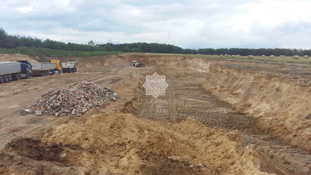
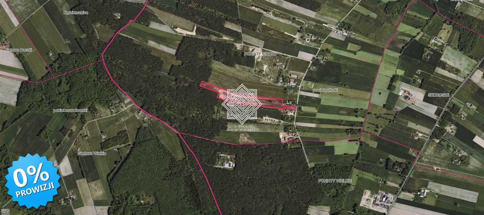
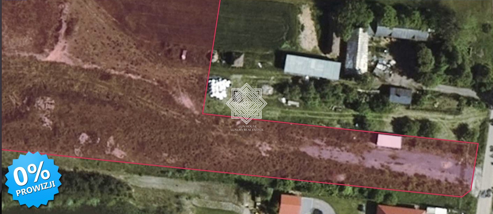
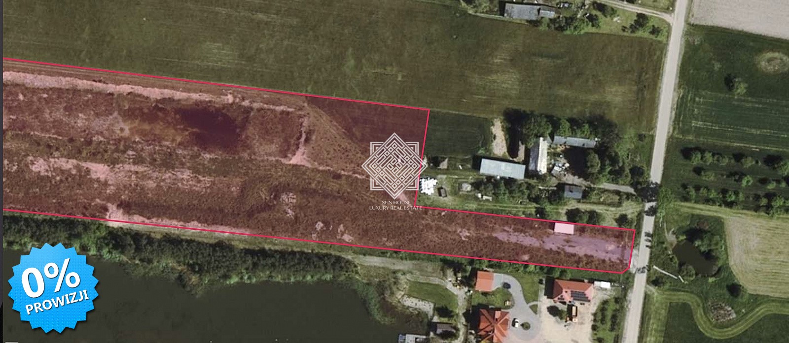
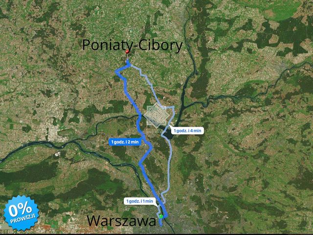
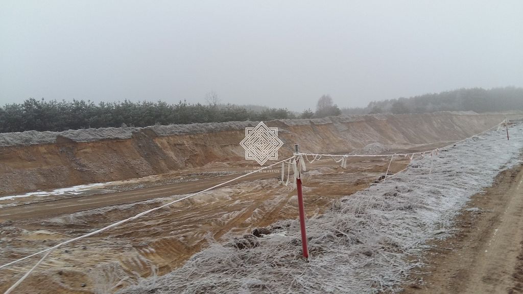
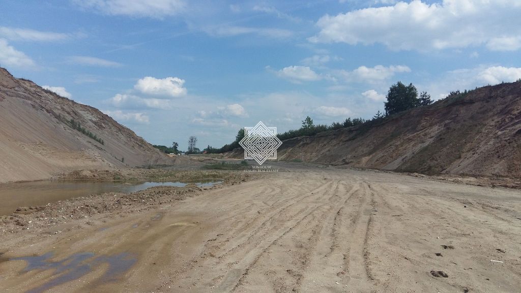
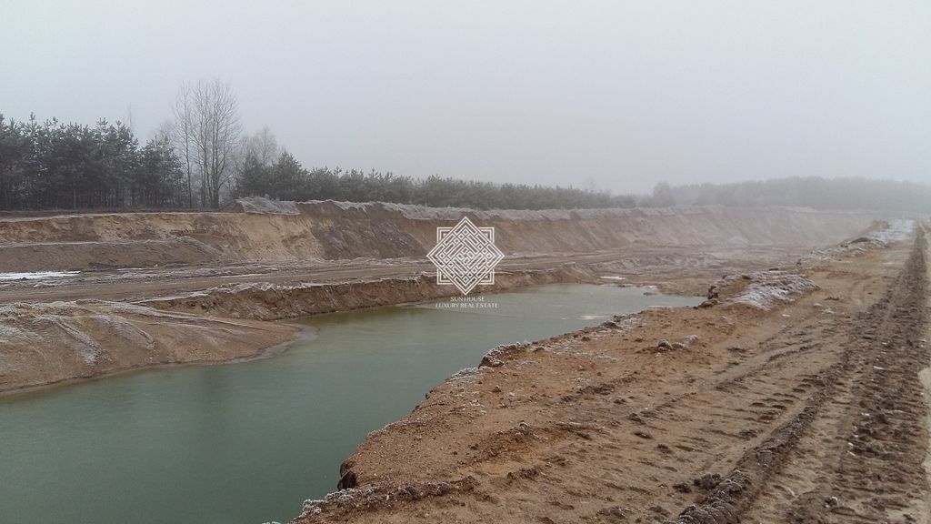
FOR SALE 50% OF SHARES. SAND AND GRAVEL DEPOSIT located on the border of 2 plots located within the administrative boundaries of the central part of the Mazowieckie Voivodeship, in the Pułtusk County, in the Winnica commune, in the village of Poniaty Cibory. This area is located approx. 7.4 km SW of Winnica, while being approx. 19.5 km SW of Pułtusk and approx. 54 km NW of Warsaw. In terms of area, the deposit with an area of 3.18 ha has the shape of a rectangle narrowing towards the west. Its central-eastern part is occupied by a vast excavation with an area of approx. 2.71 ha, within the border of which a dry layer was excavated. Groundwater lies here at a depth of 0.3 m - 1.1 m below its bottom. Between the current vertical border of the deposit and the crown of the slopes surrounding the excavation, there are still small, marginal fragments of the area untouched by mining. The western part of the deposit is a long and narrow strip untouched by extraction. The deposit was documented in the dry and waterlogged layer. At the same time, only the dry layer was documented in the above-described western section of the deposit, while in the remaining area the balance resources were documented in the form of:
- dry and waterlogged layer in isolated enclaves unaffected by the mining described above.
- the watery layer lying below the bottom of the excavation. The deposit was documented in its entirety as a balance deposit "outside the protective pillar". The price is a net price to which VAT should be added.
WE INVITE YOU TO THE PRESENTATION
::offer exported from mediaRent::
Vezi mai multVezi mai puțin
NA SPRZEDAŻ 50 % UDZIAŁÓW . ZŁOŻE PIASKOWO - ŻWIROWE umiejscowione w granicy 2 działek zlokalizowanych w granicach administracyjnych centralnej części woj. mazowieckiego, w powiecie pułtuskim , na terenie gminy Winnica , w miejscowości Poniaty Cibory. Teren ten umiejscowiony jest ok. 7,4 km na SW od Winnicy, będąc jednocześnie oddalonym o ok. 19,5 km na SW od Pułtuska i ok. 54 km na NW od Warszawy. Powierzchniowo , złoże o areale 3,18 ha ma kształt prostokąta zwężającego się ku zachodowi .Centralno - wschodnią jego część zajmuje rozległe wyrobisko o powierzchni ok. 2,71 ha , w granicy którego wydobyto warstwę suchą . Woda gruntowa zalega tu na głębokości 0,3 m - 1,1 m poniżej jego dna . Między obecną pionową granicą złoża a koroną skarp otaczających wyrobisko znajdują się jeszcze niewielkie , brzeżne fragmenty terenu nienaruszonego wydobyciem. Zachodnia część złoża to długi i wąski pasek nienaruszony wydobyciem. Złoże udokumentowano w warstwie suchej i zawodnionej . Przy czym tylko warstwę suchą udokumentowano w wyżej opisanym zachodnim odcinku złoża , natomiast na pozostałym terenie udokumentowane zasoby bilansowe w postaci :
- warstwy suchej i zawodnionej w odosobnionych enklawach nienaruszonych wydobyciem opisanych wyżej.
- warstwy zawodnionej zalegającej poniżej dna wyrobiska. Złoże udokumentowano w całości jako złoże bilansowe "poza filarem ochronnym" . Podana cena jest ceną netto do której należy doliczyć podatek VAT.
ZAPRASZAMY DO PREZENTACJI
::oferta eksportowana z programu mediaRent::
FOR SALE 50% OF SHARES. SAND AND GRAVEL DEPOSIT located on the border of 2 plots located within the administrative boundaries of the central part of the Mazowieckie Voivodeship, in the Pułtusk County, in the Winnica commune, in the village of Poniaty Cibory. This area is located approx. 7.4 km SW of Winnica, while being approx. 19.5 km SW of Pułtusk and approx. 54 km NW of Warsaw. In terms of area, the deposit with an area of 3.18 ha has the shape of a rectangle narrowing towards the west. Its central-eastern part is occupied by a vast excavation with an area of approx. 2.71 ha, within the border of which a dry layer was excavated. Groundwater lies here at a depth of 0.3 m - 1.1 m below its bottom. Between the current vertical border of the deposit and the crown of the slopes surrounding the excavation, there are still small, marginal fragments of the area untouched by mining. The western part of the deposit is a long and narrow strip untouched by extraction. The deposit was documented in the dry and waterlogged layer. At the same time, only the dry layer was documented in the above-described western section of the deposit, while in the remaining area the balance resources were documented in the form of:
- dry and waterlogged layer in isolated enclaves unaffected by the mining described above.
- the watery layer lying below the bottom of the excavation. The deposit was documented in its entirety as a balance deposit "outside the protective pillar". The price is a net price to which VAT should be added.
WE INVITE YOU TO THE PRESENTATION
::offer exported from mediaRent:: Vezi mai mult Vezi mai puțin NA SPRZEDAŻ 50 % UDZIAŁÓW . ZŁOŻE PIASKOWO - ŻWIROWE umiejscowione w granicy 2 działek zlokalizowanych w granicach administracyjnych centralnej części woj. mazowieckiego, w powiecie pułtuskim , na terenie gminy Winnica , w miejscowości Poniaty Cibory. Teren ten umiejscowiony jest ok. 7,4 km na SW od Winnicy, będąc jednocześnie oddalonym o ok. 19,5 km na SW od Pułtuska i ok. 54 km na NW od Warszawy. Powierzchniowo , złoże o areale 3,18 ha ma kształt prostokąta zwężającego się ku zachodowi .Centralno - wschodnią jego część zajmuje rozległe wyrobisko o powierzchni ok. 2,71 ha , w granicy którego wydobyto warstwę suchą . Woda gruntowa zalega tu na głębokości 0,3 m - 1,1 m poniżej jego dna . Między obecną pionową granicą złoża a koroną skarp otaczających wyrobisko znajdują się jeszcze niewielkie , brzeżne fragmenty terenu nienaruszonego wydobyciem. Zachodnia część złoża to długi i wąski pasek nienaruszony wydobyciem. Złoże udokumentowano w warstwie suchej i zawodnionej . Przy czym tylko warstwę suchą udokumentowano w wyżej opisanym zachodnim odcinku złoża , natomiast na pozostałym terenie udokumentowane zasoby bilansowe w postaci :
- warstwy suchej i zawodnionej w odosobnionych enklawach nienaruszonych wydobyciem opisanych wyżej.
- warstwy zawodnionej zalegającej poniżej dna wyrobiska. Złoże udokumentowano w całości jako złoże bilansowe "poza filarem ochronnym" . Podana cena jest ceną netto do której należy doliczyć podatek VAT.
ZAPRASZAMY DO PREZENTACJI
::oferta eksportowana z programu mediaRent:: FOR SALE 50% OF SHARES. SAND AND GRAVEL DEPOSIT located on the border of 2 plots located within the administrative boundaries of the central part of the Mazowieckie Voivodeship, in the Pułtusk County, in the Winnica commune, in the village of Poniaty Cibory. This area is located approx. 7.4 km SW of Winnica, while being approx. 19.5 km SW of Pułtusk and approx. 54 km NW of Warsaw. In terms of area, the deposit with an area of 3.18 ha has the shape of a rectangle narrowing towards the west. Its central-eastern part is occupied by a vast excavation with an area of approx. 2.71 ha, within the border of which a dry layer was excavated. Groundwater lies here at a depth of 0.3 m - 1.1 m below its bottom. Between the current vertical border of the deposit and the crown of the slopes surrounding the excavation, there are still small, marginal fragments of the area untouched by mining. The western part of the deposit is a long and narrow strip untouched by extraction. The deposit was documented in the dry and waterlogged layer. At the same time, only the dry layer was documented in the above-described western section of the deposit, while in the remaining area the balance resources were documented in the form of:
- dry and waterlogged layer in isolated enclaves unaffected by the mining described above.
- the watery layer lying below the bottom of the excavation. The deposit was documented in its entirety as a balance deposit "outside the protective pillar". The price is a net price to which VAT should be added.
WE INVITE YOU TO THE PRESENTATION
::offer exported from mediaRent::